- Home
- Walking and cycling
- Maps and plans
Maps and plans
In the Bay of Arcachon - Val de l'Eyre area walking and cycling provide good alternatives for local travel. For day-to-day needs and leisure, the area has many footpaths and cycle tracks. Various maps and tools are available to help you identify them and find the information you seek.
The cycle track network
You are, or would like to be, a cyclist for your day-to-day journeys or to discover the area?
You will find many routes to make your journeys easier. Independent cycle paths, cycle tracks or lanes, low-speed zones (30 or 20 km/h) have been established to make cycling credible, effective and environmentally friendly.
- For an overview of the whole Pays Barval : MOBI map (PDF, 2 Mo)
- Focusing on the Bay of Arcachon : Travel map
- And to cycle longer distances in the Gironde département: Gironde Tourism cycling map (PDF, 11.59 Mo)
- The 20 cycling routes on the South Bay of Arcachon (COBAS): Map "Vivez l'Agglo à Vélo" (PDF, 29.8 Mo)
Cycle route tools
Bay of Arcachon local route finder
SIBA's Bay of Arcachon site offers a cycle route-finding service. A simple tool to visualise your route. You need only enter your current location and destination and the on-line system will show you the best route.
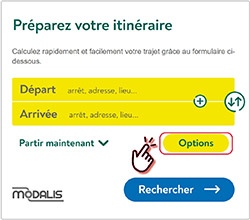
MODALIS regional multimodal calculator
 The system offers a "cycling" option when planning your journey.
Use the MODALIS research service to seek cycling routes, alone or in combination with other modes of transport.
Advantage: MODALIS tells you how much of your journey will be on specially-built cycle ways so that you can see how safe and easy it should be.
GEOVELO: a national system
Geovelo (a French start-up) provides an Internet site and iOS and Android applications offering one of the first cycling route planning tools. Its objective is to encourage bike use on a day-to-day basis. The app is free and designed to take cyclists onto roads with dedicated cycle tracks and those with little traffic.
More…
 Long-distance cycle routes are gradually being introduced throughout Europe to encourage greater use of bicycles. EuroVelo routes (EV) also encourage the development of services for cyclists (accommodation, suitable catering, equipment, maintenance and repair services, etc.).
The Bay of Arcachon - Val de l'Eyre area is crossed by the Atlantic Coast route (EV1), whose French section (the Vélodyssée from Roscoff to Hendaye) goes around the Bay of Arcachon.
For more information about local sections or the whole French route:
La Vélodyssée - Lège-Cap-Ferret / Arcachon
And to go even further afield :
EuroVelo - Atlantic Coast Route
Footpaths for discovering the region
Walking is good for personal and planetary health. Get a different view of the region when planning your outings.
 For Bay of Arcachon :
https://bassin-arcachon.com/quoi-faire/balades-a-pied-a-velo/balades-a-pied/
and https://tourisme-coeurdubassin.com/balades-randonnees/- For Val de l’Eyre :
https://rtourisme.com/6799-en-val-de-leyre.html - Walking for exercise and to discover the region also enables a great number of people to practice a healthy physical activity. The Voie de Tours – GR®655 is a branch of the route to Santiago de Compostela. Follow it at: https://www.chemins-compostelle.com/itineraires/3/la-voie-de-tours (also accessible to cyclists).
- There is also the coastal Voie de Soulac : https://ignrando.fr/fr/parcours/fiche/details/id/544648


